

Remember when you were a kid and you used to ride your beloved two-wheeler around the neighborhood? Remember the freedom, the fun, and the sound of the wind in your hair as you biked around, soaking in the sun. We may not be able to return to the carefree days of our childhood, but we can get back on our bikes and explore Virginia's bike trails with our friends and families, building new memories to last a lifetime.
10 Family Bike Rides in Virginia

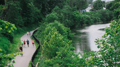
Virginia Capital Trail
The Virginia Capital Trail, which has been in the works for more than two decades, has finally been completed. The paved, signed, and well-maintained route passes through the lower James River Valley, linking Richmond and Williamsburg as well as smaller neighborhoods in between. The completed trail has a total length of 52 miles.
Learn about Virginia's early colonial past on this 13.4-mile out-and-back ride. Starting your journey at Jamestown Settlement, a living history museum situated near the first successful English settlement in the New World. In some areas, the trail runs alongside two-lane VA Highway 5. A vegetational screen between the path and the track, on the other hand, improves the trip significantly. Fields are traversed in the first segments. There are several historical markers competing for your interest. Chickahominy Riverfront Park, where the Chickahominy River and Deep Creek converge before flowing into the James River, is a good place to turn around.

Belle Isle State Park
The park, which is bordered by the tidal Rappahannock River and its tributaries, is home to a 10-mile network of trails, the majority of which are gravel doubletrack paths ideal for casual bicyclists. Since the park is relatively quiet, you can add paved bike roads to the trail system. Pedal through a wide range of wetlands, along the park's bordering waters, or through fields and forests.
The park is on Virginia's Northern Neck, a peninsula of land between the Rappahannock and Potomac Rivers in northeastern Virginia, meaning there's still water nearby. Begin your 8-mile trip at the bike rental area, then continue down Creek Landing Road to ride the Mulberry Creek boardwalk and get up next to the river. Then, following the Mud Creek Trail to the Watch House Trail, running through wetlands and woodland, go on to the Watch House Trail. Take the Neck Fields Trail to Brewers Point for more water views. Return to the trailhead and follow Porpoise Creek Trail to a wildlife blind. You can look for osprey and blue herons. Stop at a nearby picnic shelter to take in the view of the ocean and beach below.

New River Trail
The New River Trail, which stretches for 57 miles, is Virginia's longest state park. The rail trail follows a cinder bed and crosses Chestnut Creek and the New River on trestles. Your visual palate will be satiated by the occasional rapids and riverside bluffs. Pass through a 200-foot tunnel that adds mystery to an already fantastic trail. The trail is mostly forested, though it becomes more open between Foster Falls and Pulaski, where you pass Claytor Lake, a New River impoundment and home to a wonderful Virginia State Park.
Make a 14-mile round trip, start your journey at Foster Falls, which is home to a state park campground, a historic village, and stunning river views. To get to Austinville, follow the New River. After 1.5 miles, you can come to the historic Shot Tower, which was once used to manufacture lead bullets in early Virginia. When you go under I-77, take in more riverfront views. Enjoy a picnic at the Austinville entrance. Bike into an old train tunnel ahead, which will contribute to the excitement of the climb. Then there's a high trestle with a view of the New River below. Return to Foster Falls via the Ivanhoe trail entry, which is a nice spot to turn around.

Virginia Creeper Trail
The 34-mile Virginia Creeper Trail begins high in the mountains and descends through rich woods and highland streams to the trail town of Damascus, which is a lot of fun to visit. The Creeper then continues on to historic Abingdon, passing by South Holston Lake and passing through fields and woods.
Bring your bike in Damascus and then take a shuttle to Whitetop Station to reach the end of the Creeper Trail. From there, it's a 17-mile almost continuous downhill ride back to Damascus, which even the most inexperienced cyclists will complete. The mountain scenery is breathtaking, and you'll get great views of Whitetop Laurel Creek's cascades and pools as you cross several trestles over the raging waterway.

Washington & Old Dominion Trail
The W&OD is a paved, 9-foot-wide path that follows a railroad grade. It's an urban experience near Arlington, but as you travel west, it becomes more rustic. The 45-mile trail has over a dozen trailheads for easy access.
Begin at Purcellville's old train depot on the W&OD Trail's west end. Continue east through the small town, which is shaded by trees. Open up into fields and woods before heading to Paeonian Springs, about 6 miles one way, for a total of 12 miles back to Purcellville. Clarks Gap, the trail's high point, is another mile away, about 60 feet above the trail elevation in Purcellville, making for a 14-mile bike ride.

High Bridge Trail
The 31-mile High Bridge Trail runs roughly east-west between Pamplin City and Burkeville, with the trail's namesake High Bridge spanning a half-mile and rising 125 feet above the Appomattox River, providing a thrilling ride. It's one of the United States' longest recreational trail bridges. The High Bridge experience is enhanced by numerous trailhead accesses and picnic areas.
It's difficult not to want to see High Bridge, the park's namesake, so go ahead and see it. The span is a little less than 5 miles one way from Farmville, making it a 10-mile round trip experience. If you want to make the run longer, continue 3 miles from High Bridge to Rice, making it a 16-mile out-and-back. Not only are the views from High Bridge are amazing, but you can even picnic on either side of the bridge. The historical aspect is also important. The Battle of High Bridge was Robert E. Lee's last battle before surrendering to General Grant at Appomattox Court House.

Mount Vernon Trail
Arlington Memorial Cemetery, Theodore Roosevelt Island, picnic areas, and wildlife preserves are just a few of the sights along the 18-mile trail that leads to Mount Vernon. Views of the Potomac River can be found in abundance. The Mount Vernon Trail connects to other trails, such as the Potomac Heritage Trail, which is popular for bicycling.
The distance between Alexandria and Washington's estate Mount Vernon is 10 miles one way, making for a 20-mile round trip. The Jones Point Lighthouse, Belle Haven Park, and the Dykes Marsh Wildlife Preserve are all worth seeing, as is Fort Hunt Park. If 20 miles is too far for you and your family, cut it short so you have enough energy to return.

Newport News Park Bikeway
The bikeway in Newport News Park is not paved, but it is in good condition. It winds its way through the park's 7,000-plus acres of lush forest. A section of the trail connects to George Washington's Battle of Yorktown Headquarters, which is part of Colonial National Historical Park. You can continue your ride on one of the tour roads if you wish (You will share the road with cars and pedestrians here, however, speed limits are low). The Battlefield Tour is 7 miles long, and the Encampment Tour is 9 miles long. The interconnected design of the battlefield routes, on the other hand, makes shortening your path easy.
The 5.3-mile bikeway loop is enjoyable and easy to complete. Feel free to add park activities to your plans. One of Virginia's most beautiful and well-kept urban parks is Newport News Park. Most of the park can be seen from the Newport News Park Bikeway. The Battle of Dam No. 1, a designated stop on the Virginia Civil War Trails tour, is located within this large multi-purpose preserve. The National Register of Historic Places has listed this Civil War battleground. The hiker trail system that runs through the battlefield is both scenic and extensive. Take the time to enjoy Newport News Park’s attractions, which include additional trails, playgrounds, an archery range,picnic areas with shelters, a fine campground with electric and non-electric campsites, an arboretum, history displays, nature services, golf courses, and even a 30-acre model airplane field.
Roanoke River Greenway
When completed, the greenway will extend for ten miles one way, but a seven-mile portion between Ghent Park and Fallon Park, which includes the Tinker Creek Greenway, is now open to cyclists.
Vic Thomas Park, off Winchester Avenue, is a good place to start. Soon after, you'll come across Roanoke Mountain Adventures, a bike store. Trail bridges allow you to cross the water. Continue along the river in the shadow of the Roanoke Star and Mill Mountain (You can even take the Mill Mountain Greenway to the crest of Mill Mountain but it takes some serious leg power). Switch up Tinker Creek on the Tinker Creek Greenway, which will take you to Fallon Park after a 14-mile round trip. Smith Park, Wasena Park, River's Edge Complex South, and Fallon Park all have trail access on the Roanoke River Greenway. The path gives you a true sense of the city's heart and soul.

Guest River Gorge Trail
In the rugged mountains of Southwest Virginia, this rail path mixes heritage with natural beauty. Travel through the Swede Tunnel first, then take a high bridge over the Guest River, a Virginia State Scenic River. View massive streamside boulders as you continue down the cliff and bluff rimmed canyon. After passing by the first waterfall, you'll come to a stair-step cascade set in a rock-rimmed glen before reaching the trail's end at the confluence of the Guest and Clinch rivers.
Since the trail is 5.9 miles one direction, you may as well do the whole thing, making it an 11.8-mile round trip. Along the way, there are tan cliffs, waterfalls created when tributaries enter the Guest River, large boulders, streamside pools, and shoals to see. Wherever there isn't rock or trail, there grows an alluring forest. The waterway is surrounded by massive boulders that have fallen from the surrounding cliffs.


1 comment
These are beautiful rides. Next how about the DelMarVA, SE Pa area?